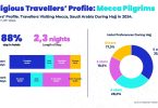
Mabrian’s latest data reveals the growing travel impact of Hajj 2025, with over 151.6 million flight seats scheduled to Mecca, in the Kingdom of Saudi Arabia — a 1.2 million seats increase compared to 2024 festivities. Most top...
Mabrian’s latest data reveals the growing travel impact of Hajj 2025, with over 151.6 million flight seats scheduled to Mecca, in the Kingdom of Saudi Arabia — a 1.2 million seats increase compared to 2024 festivities. Most top...